2.6 Geotechnical investigations in contaminated sites
Geotechnical investigations in potentially contaminated sites must follow certain procedures regarding personnel protection, avoiding contaminant migration through groundwater movement, and proper disposal of boring waste such as drilling water, soil samples etc. Some signs of possible contamination that should trigger further measures are (FHWA 2002):
- Prior land use (e.g., old fill, landfills, gas stations).
- Stained soil or rock.
- Apparent lack of vegetation or presence of dead vegetation and trees.
- Odors. Note that highly organic soils will have a rotten egg odour, which should not be mistaken as evidence of contamination. However, this odour may be indicative of highly toxic hydrogen sulphide.
- Presence of liquids other than groundwater.
- Signs of previous ground fires at landfill sites. Established landfill will emit methane gas, which is explosive.
- Presence of visible elemental metals (mercury).
- Low (<2.5) or High (>12.5) pH.
Easy-to-use methods such as air quality monitoring devices, pH measurement kits or photoionisation detectors can be used to perform preliminary tests to identify the presence of some contaminants.
Concentration of pollutants in soil and groundwater is determined via special chemical tests on soil and water samples, in the laboratory. These tests are often complemented with geophysical tests, such as electric resistivity tests or ground penetrating radar tests discussed in Part 1. The selection of the appropriate method depends on the type of pollutant.
Except of these common methods, a hydrogeological site investigation may be necessary, aiming to (CCME, 1994):
- Determine the direction and rate of groundwater movement.
- Determine the principal pathways and factors controlling the migration of contaminants in the subsurface.
- Quantify the physical parameters controlling groundwater flow and contaminant transport in the subsurface.
in other words, build the hydrogeological model of the site…
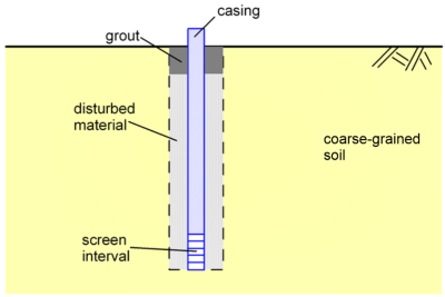
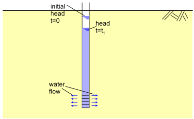
Drilling monitoring wells (Figure 2.8) may be necessary for determining groundwater levels, and water quality via samples retrieved for laboratory tests. Measuring the hydraulic conductivity (permeability) of the subsurface formations with the constant or falling head test in the laboratory or in situ (Figure 2.9) will provide the necessary input for developing a groundwater flow and contaminant transport numerical model, that can predict contamination evolution over time as described in the following chapter, and lead to the evaluation of the effectiveness of different mitigation measures.