1.1 Introduction to Part 1
Application of geotechnical engineering principles for the analysis and design of geostructures (shallow and deep foundations, earthworks etc.) is based on several soil parameters, which are used to quantify its behavior. Commonly, laboratory tests are performed to characterise and classify soils (sieve analysis, hydrometer analysis, water content measurements, Atterberg limits tests), as well as to quantify their compressibility (oedometer and constant-rate-of strain 1D compression tests), shear strength (triaxial tests, direct shear tests, etc.) and permeability (constant head and falling head tests) parameters. All these tests are performed in soil samples, which are retrieved from the area of “geotechnical interest”. The number of samples, the location from where these samples are retrieved, the depth, and the method of extraction (sampling) depend of course on the structure and its foundation properties, and are all part of the Geotechnical Site Investigation.
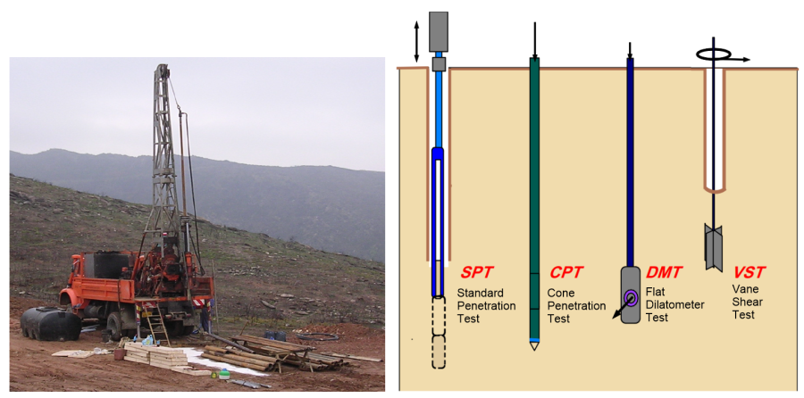
Furthermore, retrieving soil samples from boreholes and testing them in the laboratory, is often complemented with (or even replaced with) in situ tests (Figure 1.1), which offer some advantages such as minimal soil disturbance due to sampling, fast and economical testing, as well as the retrieval of continuous information along the soil profile. Typically, measurements obtained during in situ tests are not directly correlated to soil properties, and proper interpretation of measurements is necessary to derive soil parameters by means of correlation formulas.
Australian Standard AS1726 formally defines Geotechnical Site Investigation as “…the process of evaluating the geotechnical character of a site in the context of existing or proposed works or land usage”. Evaluating the geotechnical character of a site may include one or more of the following:
- Evaluation of the geology and hydrogeology of the site.
- Examination of existing geotechnical information pertaining to the site.
- Excavating or boring in soil or rock.
- In situ assessment of geotechnical properties of subsoil materials.
- Recovery of samples of soil or rock for examination, identification, recording, testing or display.
- Testing of soil or rock samples to quantify properties relevant to the purpose of the investigation.
- Reporting of the results.
During planning and implementation of a geotechnical site investigation aimed at determining all the necessary geotechnical parameters for e.g., the design of a foundation system (i.e., determine the shallow footing’s dimensions, the necessary number and length of piles etc.) the Geotechnical Engineer is called to answer certain key questions, such as:
- What is the necessary number of boreholes to obtain adequate information on the geotechnical character of the site?
- Where will these boreholes be drilled? What kind of equipment/drilling technique is appropriate for the particular site?
- What is the minimum required depth that the boreholes must reach to obtain sufficient information?
- Are any soil samples going to be retrieved for laboratory testing? How many samples are required for the proper assessment of the soil parameters? What sampling methods should be used?
- Should any in situ tests be performed to measure soil properties and, if so, what type of tests?
- Should any monitoring instruments be installed to measure groundwater table fluctuations, possible slope movements, etc.?
The results of a geotechnical investigation campaign are rarely straightforward, as subsoil itself is non-uniform: at the same site, layers of sand, clay, silt, gravels (and mixtures of them) or rock formations may co-exist. The role of the Geotechnical Engineer is to gather all this perhaps chaotic information resulting from the geotechnical investigation, including results from laboratory and in situ tests, and properly interpret them so as to:
- Explicitly define layers of different soil (or rock) formations, that exhibit the same behavior in terms of engineering response, and thus can be described by a single set of compressibility, shear strength and permeability parameters.
- Provide characteristic values of the shear strength, compressibility and permeability parameters of each one of the layers, suitable for the safe and economic design of the planned geotechnical works.
- Identify the groundwater table level and its possible variation within the lifetime of the project.
…in other words, built the “geotechnical model” of the site
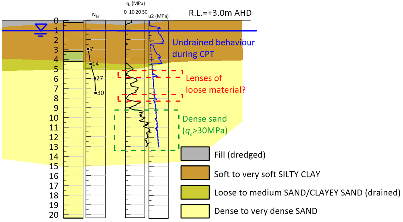
Usually these results are reported in the form of geotechnical cross-sections (Figure 1.2), where the geometry and the extent of the different geotechnical layers is graphically depicted, together with groundwater table levels, key results from in situ tests, and any other critical information on the project. Description of geotechnical layers must be accompanied by lists/tables containing the interpreted characteristic values of the parameters required for the analysis of the behaviour and the design of geotechnical works.
Additionally, a geotechnical investigation and interpretation report should provide information regarding:
- Potential geological hazards e.g., earthquakes, landslides.
- Dewatering requirements during construction.
- Stability of temporary works during construction e.g., cuts.
- Potential effect of works on existing nearby structures, including cracks due to differential settlement, slope instability, effects of construction vibration due to possible pile driving etc.
- Construction access issues.
Certain key components of a geotechnical investigation campaign are described in the following chapters.
